In our last “Continuing up the Hill” post we described the acquisition of the Warren property in 1905 following the fire which destroyed the Main Building. Along with a house and stable, the property contained 10.5 acres. During the next two years the Institute purchased more land. A small 0.81 acre parcel was purchased from the Troy Hospital (the present West Hall) and 1.41 acres in two parcels from the Warren and Tibbits estates. These two parcels were the first Institute properties to border on Fifteenth Street. In 1907 a 10.6 acre parcel was purchased from St. Joseph’s Seminary, whose main building occupied the present site of Folsom Library. Added to the 1.7 acres purchased with the Rankin house in 1877, the Institute now owned 25 acres east of Eighth Street.
The property was very irregular in surface. An east-west ravine ran through it and there was a stream and pond of considerable size called College Pond. The pond was located at the northeast edge of what is now the ‘86 Field and extended north to the top of the ravine. The pond was filled in 1907-08 with clay from a large hill at the east end of the athletic field. In 1908 a street called Avenue B (now Sage Avenue) was cut through the ravine from Ninth to Fifteenth Streets, a continuation of Federal Street. The street cut through part of what had been College Pond. 
We have been unable to locate any photographs of College Pond, but we do have two images, both from maps. The first, compiled by Weise & Bardin of Troy in 1876, shows the pond east of the Troy Hospital (current West Hall). The pond’s eastern edge is abutting Thirteenth Street. We think this section of Thirteenth Street was a figment of the cartographers’ imagination. There is no evidence the street crossed the ravine and cut south through what became the Rensselaer campus. (Thirteenth Street is interrupted at Peoples Avenue directly opposite the entrance to the North Parking Lot and then continues south of College Avenue.) The map also shows a stream at the east side of the pond. 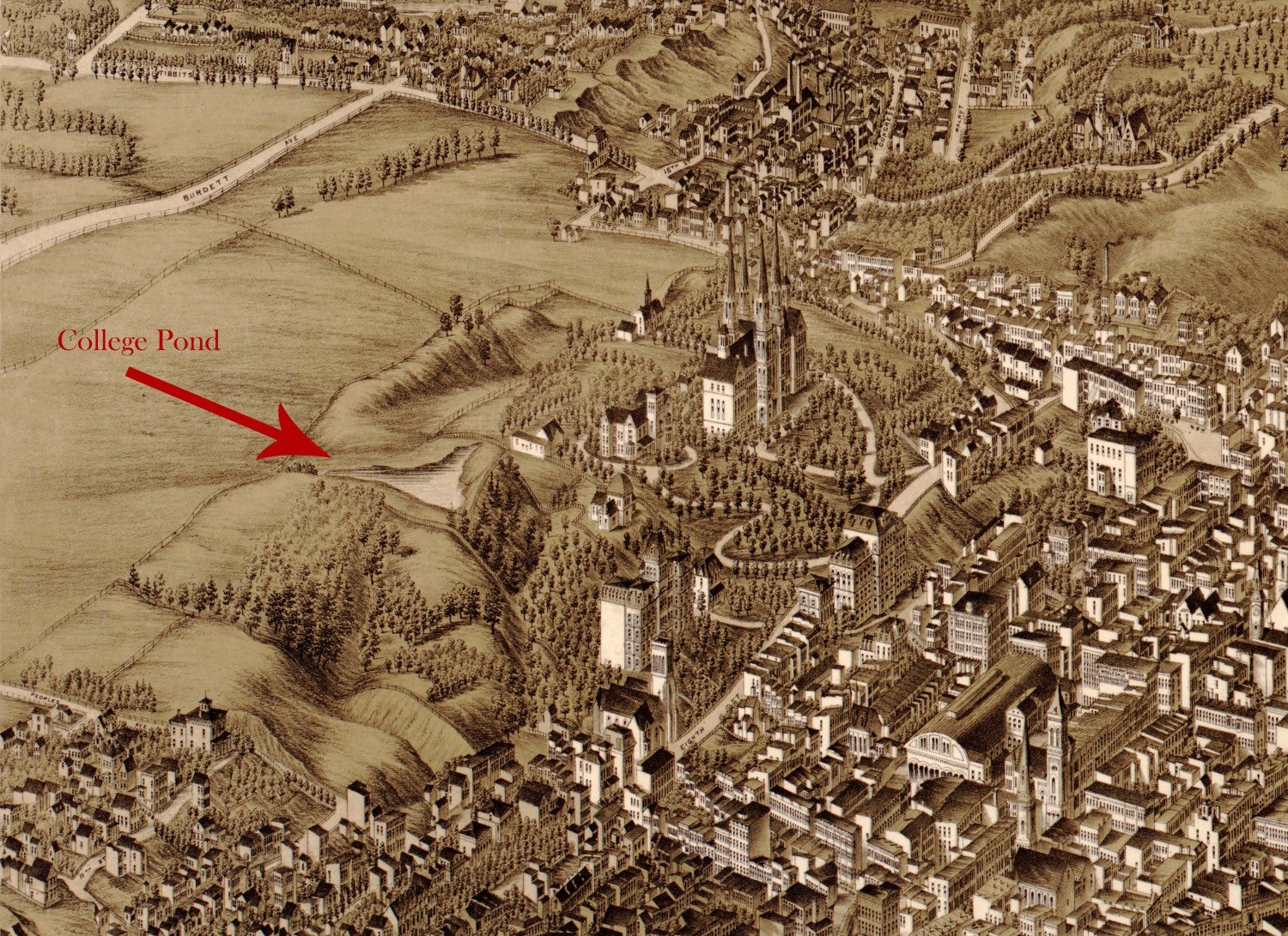
The second image of the pond is from a wonderful 1881 panoramic map of Troy from the Library of Congress (follow link above to view the entire map of Troy). The map clearly shows the triangular shaped pond and the ravine to the east of the Troy Hospital and notably shows no streets crossing the area between Eighth Street and Burdett Avenue.
Comments
Good Morning,
This was wonderful to find in Morning Mail!! Thank you for finding these maps and images and putting them up. Is there a link to the map image? The timing on the slides makes studying the map difficult. The LOC image is wonderful.
Thank you for this insight,
Bill Bergman
SoA Fabrication Manager
In reply to by egglel
Hello Bill - Thanks for reading! You can pause the slide to review the map for a longer period of time. There's a pause icon in upper right corner of the slide.